
2026-07-19
What Are Geospatial Annotation Services? A Complete Guide for AI, GIS and ADAS Projects
Learn what geospatial annotation services are, including LiDAR annotation, HD map annotation, satellite imagery, GIS annotation, and geospatial data labeling workflows.
What Are Geospatial Annotation Services? A Complete Guide for AI, GIS and ADAS Projects
Geospatial AI projects fail for one reason more than any other: the training data was not accurate enough.
Not because the model was wrong. Not because the sensor was cheap. Because the annotated dataset underneath the model did not reflect the real world with enough precision to be trusted in production.
At ASPL, we have delivered geospatial annotation across 15 documented projects spanning automotive Tier-1 programmes, civil infrastructure, utilities, telecom, railways, and environmental monitoring. With 98% or above annotation quality, TISAX AL3 certification, and delivery across 800 square kilometers of LiDAR data and 5,500 HD scans, we understand what reliable geospatial annotation actually requires at scale.
This guide covers what geospatial annotation services are, how they work, where they are applied, and what to look for when selecting a partner. Whether you are building an autonomous driving perception stack, a utility inspection AI, or a large-scale GIS mapping project, the principles here apply directly.
What Is Geospatial Annotation?
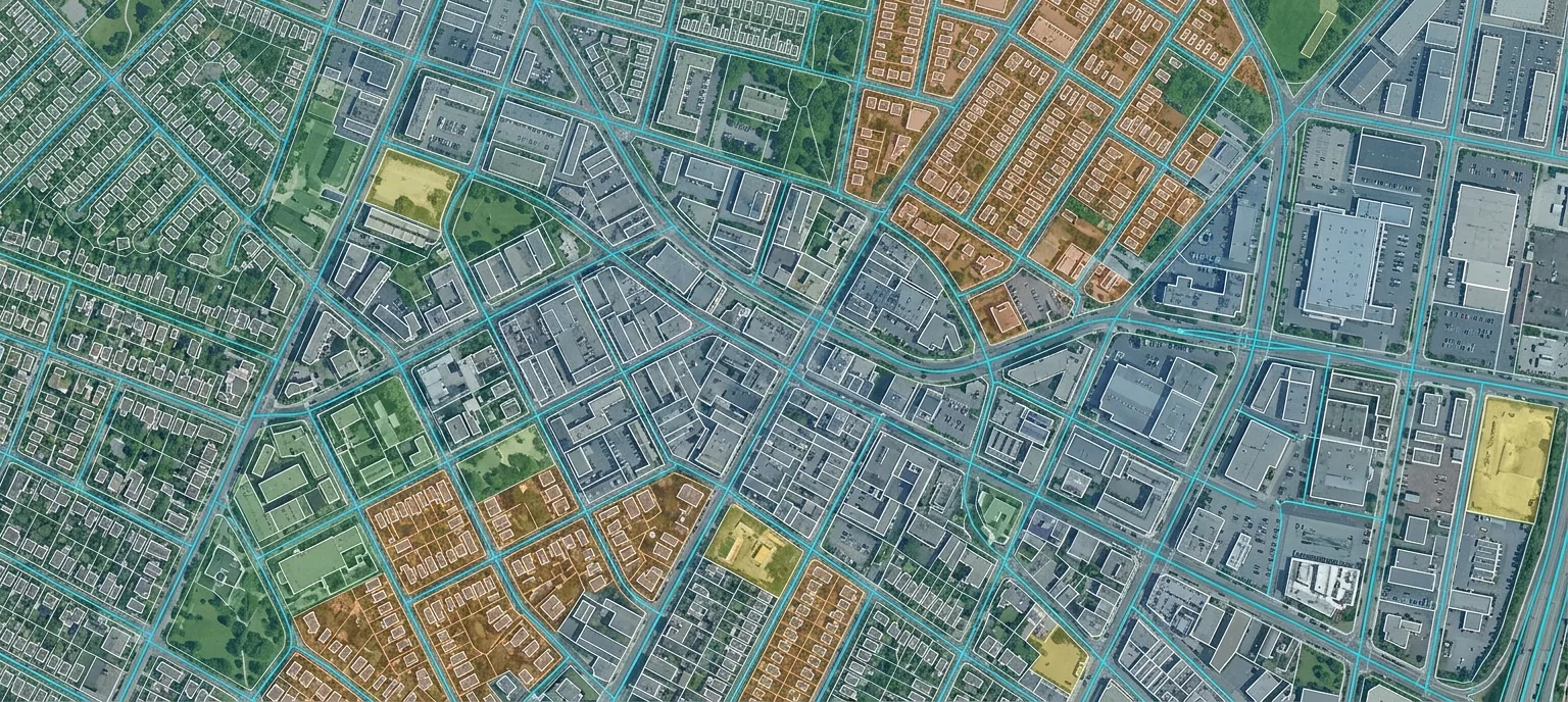
Geospatial annotation services involve labeling satellite imagery, LiDAR point clouds, drone imagery, GIS maps, and HD maps to create structured training datasets for AI and machine learning models.
Unlike standard image annotation, every label in a geospatial dataset carries a geographic coordinate that positions it precisely on the earth's surface. A polygon annotating a building footprint is not just a shape. It is a georeferenced boundary aligned to a specific coordinate system, linked to attribute data, and accurate to within a defined spatial tolerance.
This is what makes geospatial data labeling fundamentally more demanding than general computer vision annotation. Geospatial AI applications require higher positional accuracy and consistency than conventional image annotation projects. A misplaced polygon in a general dataset produces a training error. A misplaced polygon in a geospatial dataset can put a road centerline in the wrong lane, cause an HD map to misrepresent an intersection, or produce a utility network map that sends a maintenance crew to the wrong location.
Geospatial annotation services cover the full range of this work: from ingesting raw satellite imagery, LiDAR point clouds, or drone orthophotos, through labeling and classification, to delivering production-ready datasets in OGC-compliant formats that downstream AI pipelines and GIS systems can use directly.
Why Geospatial Annotation Matters in AI
The quality of annotated data is one of the most important factors influencing AI model performance. For spatial AI, this dependency is especially direct.
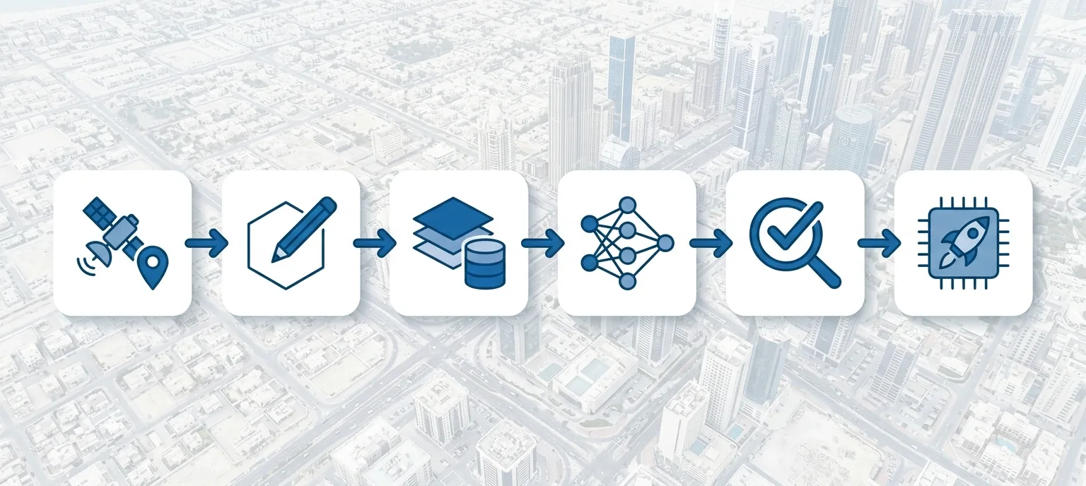
The journey from raw spatial data to a production AI system follows a clear sequence:
Raw Spatial Data — satellite imagery, LiDAR point clouds, drone orthophotos, engineering drawings
Annotation — labeling, classifying, and attributing spatial features with geographic precision
Training Dataset — structured, validated, format-compliant data ready for model ingestion
Model Training — the AI model learns from annotated examples what features look like and where they are
Validation — model accuracy is tested against ground truth datasets before production release
Production AI — a deployed system performing reliably in real environments at scale
A well-annotated training dataset improves model accuracy, reduces retraining cycles, and ensures the AI system generalizes reliably across the geographic and environmental conditions it will face in the field. Errors introduced at the annotation stage do not stay at the annotation stage. They propagate through every subsequent step and are significantly more expensive to fix after model training than before it.
Types of Geospatial Annotation
Different data types require different annotation approaches. Geospatial annotation services span several distinct categories, each with its own toolchain, quality requirements, and delivery standards.
Satellite Imagery Annotation
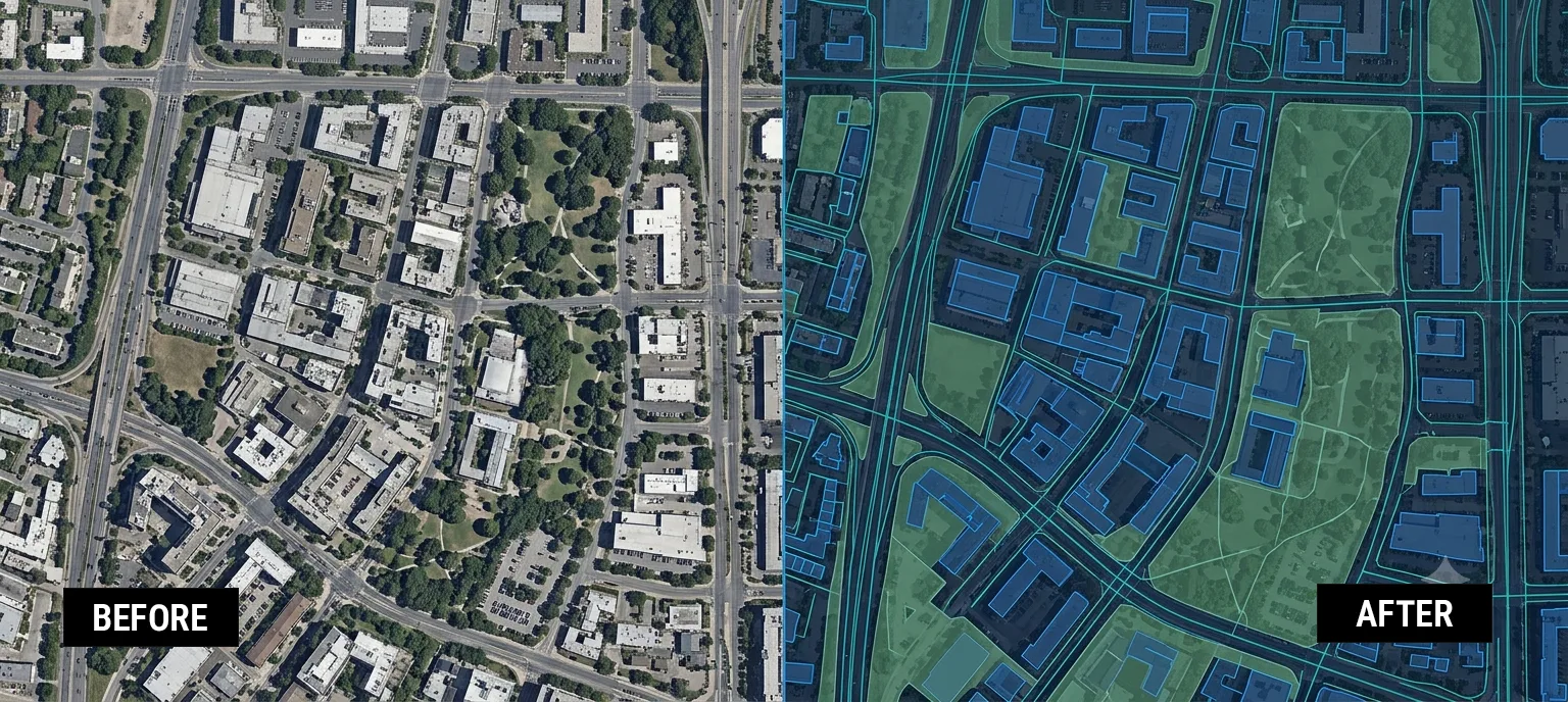
Satellite imagery annotation involves labeling features from images captured by orbital or high-altitude sensors. Resolution varies from sub-30cm imagery, where individual vehicles and building edges are distinguishable, to 10-meter imagery, where an entire small building can disappear into a single pixel.
Common tasks include building footprint extraction, road network digitization, land use classification, flood extent mapping, and change detection between multi-temporal image pairs.
LiDAR Annotation Services
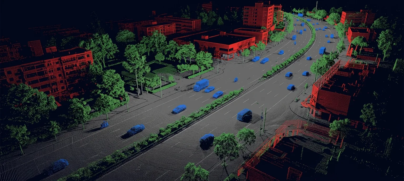
LiDAR sensors emit laser pulses and build dense, three-dimensional point clouds of the surveyed environment. LiDAR annotation services involve classifying those points into meaningful categories: ground, buildings, vegetation, water, roads, vehicles, and infrastructure features. Data is stored in LAS or LAZ format, the industry standards for point cloud exchange.
For ADAS applications, LiDAR provides the depth information cameras alone cannot reliably supply. Annotating LiDAR data for safety-critical autonomous driving development requires annotators who understand sensor physics, coordinate alignment, and the classification hierarchies the use case demands.
ASPL has classified 800 square kilometers of LiDAR point cloud data across road infrastructure mapping, building and vegetation extraction, and ground truth dataset creation for autonomous navigation programmes.
HD Map Annotation
HD maps are designed to provide lane-level or centimeter-level accuracy depending on the mapping workflow and application. They encode lane boundaries, road markings, traffic sign positions, intersection geometry, and static infrastructure at the precision that autonomous vehicles and ADAS systems need for localization and path planning.
HD Map Annotation combines LiDAR point cloud classification, image-based lane marking detection, and polyline annotation to represent road geometry at the fidelity ADAS development demands. For projects requiring compatibility with autonomous driving software stacks, annotation outputs can be structured to align with OpenDRIVE format specifications.
ASPL has annotated 5,500 HD scans for Tier-1 automotive clients, covering lane borders, centerlines, and intersection lines across complex urban scenarios.
Drone Image Annotation
Drone or UAV imagery provides higher resolution than satellite coverage and can be captured on demand for specific project areas. Drone image annotation covers labeling from aerial RGB imagery, multispectral data, and thermal camera feeds.
For power line corridor inspection, annotators label transmission towers, conductors, insulators, and vegetation encroachment from UAV RGB and thermal imagery, enabling AI models to detect structural faults and clearance violations without manual inspection of every span.
GIS Annotation
GIS annotation refers to the labeling and digitization of features within geographic information systems: parcel boundary digitization, utility network feature extraction, road centerline capture, and attribute tagging. It typically involves working from scanned engineering plan drawings or existing GIS datasets that require correction and enrichment. Outputs are delivered in Shapefile, GeoJSON, geodatabase, or DXF format depending on downstream system requirements.
Common Annotation Techniques
A capable geospatial annotation services provider should be proficient across all standard annotation techniques.
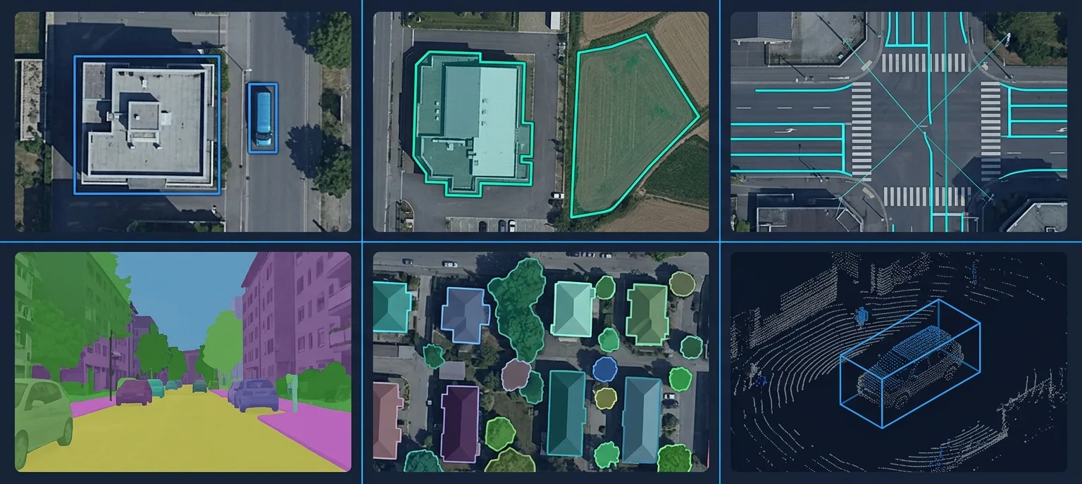
Bounding boxes define the rectangular extent of an object within an image. Used for locating buildings, vehicles, and infrastructure elements where pixel-level precision is not required.
Polygon annotation traces the actual outline of a feature. Standard for building footprint extraction, land parcel digitization, field boundary mapping, and road surface delineation.
Polyline annotation traces linear features: roads, lanes, pipelines, power lines, rivers, and rail tracks. For HD map production, polylines capture lane boundaries and centerlines at ADAS-grade precision.
Semantic segmentation assigns a class label to every pixel in an image. Used for LULC classification and road scene understanding in autonomous driving applications.
Instance segmentation extends semantic segmentation by distinguishing individual instances of the same class, useful for counting and tracking discrete objects such as buildings, vehicles, or trees.
3D cuboids define the three-dimensional bounding volume of objects in LiDAR point cloud data, capturing position, size, and orientation. Essential for 3D perception model training in autonomous vehicle programmes.
Applications of Geospatial Annotation
Autonomous Driving and ADAS
Autonomous vehicles and ADAS systems are the largest consumers of geospatial annotation. HD map production, LiDAR point cloud annotation for 3D perception, and satellite imagery annotation for scene understanding all feed into the AI stack that modern vehicles depend on. Annotated datasets are essential for training, validating, and benchmarking the perception models that interpret sensor data in real-world driving conditions.
Smart Cities and Urban Planning
Smart city platforms use annotated satellite and drone imagery to monitor urban growth, track construction, measure green space, and assess infrastructure condition. Cadastral mapping, the digitization of land parcel boundaries, underpins property taxation, land administration, and infrastructure planning at city and regional scales.
Utilities and Infrastructure
Utility companies use geospatial annotation to build AI systems that detect cable faults from drone thermal imagery, identify vegetation encroachment along transmission corridors, and map underground pipeline networks from engineering plan drawings. ASPL annotated 150 to 200 utility plan sheets covering water, sewer, and storm infrastructure for a civil engineering client, delivered as a version-controlled GIS database in Shapefile and GeoJSON formats.
Railways
Railway operators use annotated geospatial data to monitor track condition, detect encroachment into rail corridors, map trackside assets, and support automated inspection programmes using drone and satellite imagery.
Telecom
Telecom operators use annotated geospatial datasets to plan and maintain network infrastructure: antenna position mapping from aerial imagery, cable route digitization from survey data, and span correction projects that digitize and validate the positions of utility poles, cables, nodes, and service connections.
Mining and Environmental Monitoring
Mining operations use annotated LiDAR and satellite data to monitor excavation progress, track stockpile volumes, and detect ground subsidence. Environmental monitoring applications include LULC change detection, forest cover mapping, flood extent estimation, and tree health assessment using multispectral satellite data and vegetation index analysis.
Agriculture
Agricultural AI uses annotated multispectral and hyperspectral satellite imagery to classify crop types, estimate yields, detect pest and disease stress, and monitor soil moisture at field and regional scales.
Tools Used for Geospatial Annotation
The right toolchain depends on data type, required output format, and project scale.
QGIS: is the open-source standard for vector GIS annotation, used for polygon, polyline, and point feature digitization. PyQGIS enables Python-scripted automation of repetitive GIS workflows and batch data processing.
ArcGIS Pro: is the enterprise GIS platform for large-scale spatial data management, thematic mapping, and geodatabase creation. ArcPy provides scripting capability for automated map generation and spatial analysis.
AutoCAD Map 3D: is the standard tool for GIS annotation sourced from engineering drawings, combining CAD precision with GIS data management for infrastructure and utility mapping projects.
MicroStation: is used for engineering-grade feature extraction from LiDAR point clouds, particularly for road asset mapping, utility network digitization, and HD map ground truth production.
CloudCompare: is the open-source standard for LiDAR point cloud QC, classification, and 3D feature extraction, supporting LAS and LAZ format inputs and GeoJSON outputs.
AI-Assisted Annotation Platforms
Alongside industry-standard GIS software, enterprise projects increasingly use AI-assisted annotation platforms to improve productivity and consistency at scale.
ASPL's PIXEAL platform supports AI-assisted image annotation workflows for satellite imagery and drone orthophotos through automated pre-labeling, project management, quality tracking, and human expert review. Rather than replacing GIS software such as ArcGIS Pro or QGIS, PIXEAL complements existing workflows by accelerating large-scale annotation projects while maintaining the human validation layer that production-grade annotation requires.
Geospatial Annotation Workflow
A structured, repeatable workflow separates annotation delivered at enterprise scale from one-off project work.
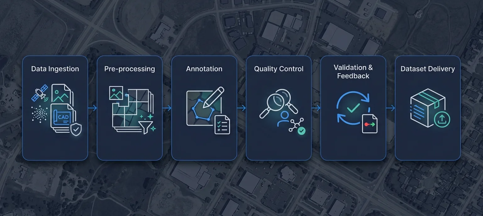
Data ingestion: starts with format validation, coordinate system verification, and quality assessment. Raw data arrives as GeoTIFF satellite imagery, LAS or LAZ LiDAR point clouds, DWG engineering drawings, or drone orthophotos.
Pre-processing: prepares data for labeling: image mosaicking, radiometric correction, point cloud noise removal, coordinate system transformation, and tiling into manageable annotation chunks.
Annotation: is performed against detailed guidelines specifying class definitions, minimum feature sizes, attribute requirements, and worked examples for common edge cases.
Quality control: runs through a two-tier structure: primary annotators reviewed by quality analysts, with automated topology validation between stages to catch connectivity errors and class label inconsistencies.
Quality feedback and validation: closes the loop. After initial QC, datasets go through a structured correction cycle: errors are documented and resolved, edge cases are added to the annotation guidelines, and the corrected dataset goes through final validation against ground truth data before approval. This stage ensures the delivered dataset is not just annotated, but reliable.
Dataset delivery: is staged by area tile or annotation batch, with version control maintained across the dataset to manage corrections and additions over the project lifecycle.
Common File Formats
Understanding delivery formats is a practical requirement for any team evaluating geospatial annotation services.
GeoJSON is the OGC-compliant open standard for vector geospatial data, supported across GIS platforms, web mapping tools, and AI frameworks. Shapefile (.shp) remains the most commonly specified delivery format for utility mapping and cadastral projects. LAS and LAZ are the industry standards for LiDAR point cloud data, with LAZ being the compressed variant. DXF is AutoCAD's exchange format and is standard for engineering drawing digitization. KML is used for feature visualization and basic data exchange in utility and infrastructure contexts. SVG is used for vector road network annotation in HD map workflows.
Challenges in Geospatial Annotation
Scale. A single satellite coverage run can produce terabytes of imagery. Maintaining annotation consistency across hundreds of square kilometers, without quality drift, requires structured team management and tooling capable of handling large raster datasets.
Coordinate system management. Mixing coordinate systems without correct transformation produces systematic positional errors that propagate through the entire downstream pipeline.
Occlusion and ambiguity. Buildings occlude road features beneath their eaves. Dense vegetation obscures ground points in LiDAR data. Annotators must apply domain knowledge to resolve these ambiguities consistently.
Resolution variation. The same feature looks different at different image resolutions. Annotation guidelines must specify how resolution-dependent decisions are handled across tiles.
Team consistency at scale. Maintaining annotation consistency across a large team over a long project requires a structured process for raising, documenting, and resolving guideline edge cases as they appear in real data.
How to Choose a Geospatial Annotation Partner
Demonstrated accuracy: Providers should be able to demonstrate comparable project experience and measurable quality metrics. Ask for accuracy reports against known ground truth datasets, not headline percentages without a verifiable process behind them.
Security certifications: For projects involving sensitive infrastructure data or client-proprietary engineering drawings, TISAX AL3, ISO 27001, and GDPR compliance are requirements. Confirm the provider holds the certifications relevant to your data type and geography.
Delivery capacity: Volume and timeline commitments need to be backed by actual team structure: annotator headcount in the relevant specialisation, the QC ratio, and documented throughput per annotator-day for your annotation type.
Domain expertise: Annotation for ADAS development requires understanding of HD map specifications and validation requirements. Annotation for utility mapping requires familiarity with civil engineering drawing conventions. Expertise should be verifiable through relevant case studies.
QA process depth: Ask how many QC stages the workflow includes, what the annotator-to-analyst ratio is, and what automated validation tools run between stages. A documented, multi-stage process is meaningfully more reliable than a headline accuracy figure without a verifiable method behind it.
Supported formats: Confirm the provider delivers in your required output formats. GeoJSON, Shapefile, LAS, LAZ, DXF, and geodatabase each have format-specific production requirements that differ in practice.
Why Enterprises Choose ASPL for Geospatial Annotation Services
ASPL's Geospatial Annotation Services combine domain expertise, scalable delivery, and a QC infrastructure built for enterprise AI projects.
Across documented projects, ASPL has:
Annotated 5,500 HD scans for Tier-1 automotive clients, covering lane borders, centerlines, and intersection lines in complex urban scenarios
Classified 800 square kilometers of LiDAR point cloud data for road infrastructure and building extraction
Delivered 1,000 square kilometers of building footprint extraction from aerial video data with tight and precise bounding box accuracy in Shapefile format
Completed 15 geospatial case studies spanning LULC mapping, cadastral mapping, HD road networks, LiDAR classification, utility network mapping, power line inspection, and automated change detection
Projects are delivered through a multi-level quality assurance process targeting 98% or above annotation accuracy, enforced through a structured QA structure with automated topology validation running between annotation stages and at final delivery.
ASPL holds TISAX AL3, ISO 27001:2022, ISO 9001:2015, and EU GDPR certifications, meeting the information security and data protection requirements of automotive Tier-1 suppliers and infrastructure companies as a baseline.
ASPL's PIXEAL platform supports AI-assisted annotation workflows for satellite imagery and drone orthophotos, accelerating large-scale image annotation projects while maintaining the human expert review layer that ADAS and infrastructure applications require.
Conclusion
As AI adoption expands across transportation, utilities, infrastructure, environmental monitoring, agriculture, and smart cities, the demand for high-quality geospatial training data will continue to grow.
Choosing the right geospatial annotation approach is not simply about labeling spatial data. It is about creating reliable datasets that enable AI systems to perform consistently in real-world environments, on the roads, in the field, and across infrastructure that people depend on every day.
Whether your project involves satellite imagery, LiDAR point clouds, HD maps, drone imagery, or GIS datasets, a structured annotation workflow and rigorous quality assurance are the difference between training data that works in testing and training data that holds up in production.
If your organisation is evaluating a partner for Geospatial Annotation Services, ASPL is ready to help. Our team has delivered enterprise-scale annotation across automotive, utilities, telecom, railways, civil infrastructure, and environmental monitoring.
Contact our team to discuss your project or explore our Data Annotation Services and AI Training Data Services for related requirements.